Raymond Smith, Architect of Incline Village
December 28, 2022 | Member Submitted
Written by rich
Once Art Wood’s team of Oklahoma investors had secured the purchase of some 9,000 acres of mostly second growth forest land on the northern shores of Lake Tahoe from George Whittell in 1959, nothing more determined the look and feel of the community they planned to create than the efforts of one Raymond M. Smith. Smith’s name and accomplishments are often lost in accounts of the history of Incline Village but Raymond is pretty much responsible for creating the actual design of the community we now call home.
Born in San Francisco in 1923, only child Raymond graduated from Lowell High School and then enrolled in nearby Stanford University. When WWII changed everybody’s plans he enlisted in the Army Air Corps and then served as a B-24 bombardier on the Italian front beginning in 1944. After the war Lt. Smith returned to Stanford to complete his BA degree and then continued his education at Harvard University where he was in the first class to earn a masters degree in city planning in 1949. Smith became Nevada’s first professionally trained city planner and in1960 left his position heading Washoe County’s planning department to accept Art Woods’ offer to lay out the plans for the new town Crystal Bay Development Company was about to build which Wood suggested would become “the Pebble Beach” of Lake Tahoe.
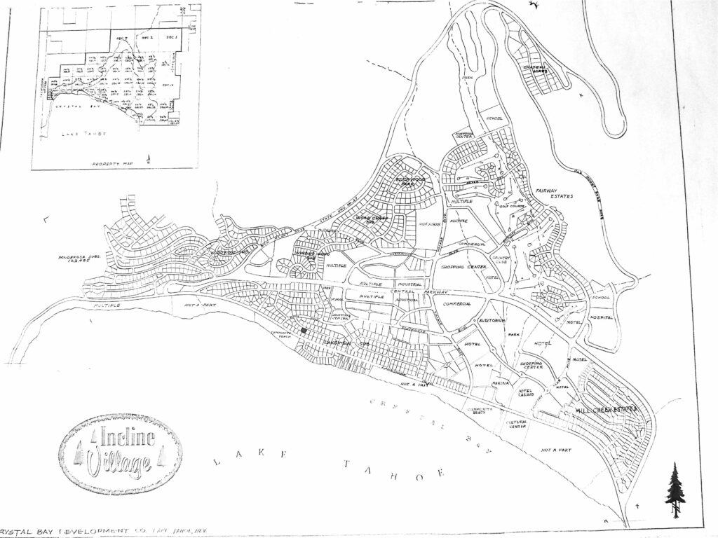
What follows is an introduction to Raymond Smith’s vision of what the town he first suggested be named “Incline Village”—emphasis on the Village part—for locals nearby had long referred to the area as “Incline” as one might casually refer to other areas around the Lake as “South Shore” or “Spooner.” The map spread across this page and the next is what is believed to be Smith’s final first plan for Incline Village. It was probably finished in late 1960 or early1961 and the original draft from which this is copied contained on the upper left hand corner a grid which called out the planned section quadrants which are not relevant here. What this author hopes readers will find of most interest in viewing this map is to realize that Smith’s plan—reflecting Wood’s et all vision for Incline Village—is remarkably consistent in many respects with what we see about us today. In other critical regards it differs considerably from what was originally drawn.
In interviewing two of Raymond’s surviving sons for the article, Gage Smith, who still lives in the Minden/Gardnerville area for part of the year near his brother Cole, said that one of the first things you need to understand about Raymond’s plans “was that he hated straight lines.” Raymond also had an abiding respect for the land, and his designs always attempted to reflect what Mother Nature had done with the surface of the earth. In fact starting at a very early time in his career in Nevada, Raymond spent much of his free time traveling to every corner of Nevada and nearby states exploring old ghost towns and defunct mining operations and documenting them with amazingly accomplished drawings and water color paintings. Smith wrote about these journeys in a dozen books—many still available on line. His boys accompanied him on many of these trips, and those stories are fascinating reads but for another time. Before putting pencil to drafting paper Raymond walked almost every square yard of Incline and the mountain sides around it, and spent hours talking with Art Wood and partner Harold Tiller to identify all the elements of the community they proposed to create, and then he went to work,
The original offices of the Crystal Bay Development Company were on the lower floors of Eugene’s Crystal Bay Chalet, a trendy restaurant off the lake side of highway 28 going up the hill into Crystal Bay. Raymond’s office and drafting tables were in that office and unfortunately for historians trying to document those early days, the restaurant and CBDC offices were destroyed in a “suspicious” fire on New Year’s Eve,1960. But by that time the layout and plans for the new community were well along and Raymond continued his work from the (ironically) Swiss Chalet style home he had built for his family on Shoreline Circle while CBDC found new digs. Raymond Smith completed his work in 1963 and although the family continued to live in Incline Village where his sons attended area schools, he himself opened a consulting business in Reno and commuted over the newly reconstructed Mount Rose Highway until the family moved to Reno in 1964. The Smiths moved back again to Incline in 1968 where son Cole was a member of the new Incline Village High School’s first graduating class.
So let us now consider several key aspects of Raymond Smith’s original plan for Incline Village.
First, please note that the plan shows only a small portion of the shoreline along Lake Tahoe to be available for development. This is because a good portion of that land had already been sold by George Whittell and although it was later included in the jurisdiction of the Incline Village General Improvement District, it was not included in the land which CBDC had purchased.
Second, Lakeshore Blvd. which was the original path of traffic through the area was to be bypassed by a new road called on the map “Central Parkway.” The junction between that new road and the “New Mount Rose State Hwy. No. 27” was planned to “T” into Lakeshore Drive near where the exact opposite now happens—Lakeshore T’s into SR 28 as the Central Parkway has since been numbered.
Third, the “Old Mount Rose Road” (SR 431) which left Country Club Drive just east of the Central Parkway (now route 28) was planned to parallel the new alignment of SR 431 along the latter and above a new neighborhood development labeled Chateau Acres where the lot sizes were to be much larger and more expensive than many of the other lots platted down below. According to Paul Franklin, a local builder who was a contemporary of the Smith family back in the day, Chateau Acres was one of the first subdivisions to be developed in Incline even though it was farthest from the lake. Paul remembers that the other neighborhoods that were first developed by CBDC in addition to Chateau Acres were Ponderosa (where the Tiller family built), Woodridge, Lakeview (where the Wood and Smith families built), and Millcreek.
Fourth, although the map does not show utilities, they were a major consideration and all electrical and phone service was to be above ground except for Shoreline Circle which was planned as one of the most prestigious neighborhoods and those utilities placed underground from the start. All waste disposal (sewers) were initially via septic systems and that fact determined lot sizes initially. Later, Village sewers had to be underground and a treatment plant built to comply with increasingly strict regulations promulgated by the TRPA starting in the late 1960’s. This was a massive project and part of the reason CBCD sold to Boise Cascade in 1968.
Fifth and very critical, the center of activity for the new town was planned to be arranged around a yacht harbor to be built where the Village Green now sits and surrounded by half a dozen large hotels, hotel casinos and motel complexes. The area was to house a park which would stretch from the Central Parkway all the way down to the yacht harbor and would also include an upscale shopping center with a north/south boulevard punctuated by traffic circles crossing the area between the Mill Creek Estates and a commercial area at the junction of Village Blvd and the Central Parkway.
Sixth, a High School was to be located exactly where it was subsequently constructed. The first golf course and “Country Club” were also located where subsequently built. Two “Community Beaches” were located where Ski and Burnt Cedar beaches exist today.
Seventh, a large shopping center was to be situated in the whole area where the Raleys supermarket stands today using only a small part of what was originally envisioned. Several other school sites were specified as was as a hospital to be built in what is now the residential area at the start of the Old Mount Rose Road just above Country Club Drive.
Lastly, at least for this overview, half a dozen areas were designated “Multiple” for apartment and condominium construction for what one might well imagine was later to be called “workforce housing” with one such area even bordering the lake on the way to Crystal Bay. None of the current town above Mount Rose Highway (now Tyner Road, etc.) was proposed in the original plan except for the aforementioned Ponderosa and Woodridge Subdivisions close to present SR 28.
So please now consider the original vision Raymond Smith and his colleagues had for our community and ponder how things evolved for better or worse over the next sixty years.